Jamestown
NOTE: Please read parking and access infomation carefully before visiting Jamestown. Failure to follow the rules will threaten our access to this crag.
General information
Land Manager: Southeastern Climbers Coalition
Native Lands: ᏣᎳᎫᏪᏘᏱ Tsalaguwetiyi (Cherokee, East) , S’atsoyaha (Yuchi) (from Native-land.ca)
Area Rep: Scott Perkins, alpstyle@comcast.net
The SCC purchased Jamestown in May 2015, forever opening this once banned crag. The Jamestown climbing area is comprised of nearly one mile of 80 to 100 foot tall sandstone climbing cliff located in northeastern Alabama. Situated above the town of Jamestown, this area has a long history of climbing dating back to 1977. The area was discovered by visiting climbers Rich Gottlieb and Chick Holtcamp, who were touring the Lookout Mountain area and climbing at nearby Yellow Creek. In time, Jack Chislet, Eric Zschiesche, John Vermont, Shannon Stegg, Gene Smith, Mark Cole, Rob Robinson and Chris Watford would all put up new routes on the sandstone cliffs called Jamestown. Today the area boasts many superb lines and a large concentration of 2 and 3 star routes.
Directions
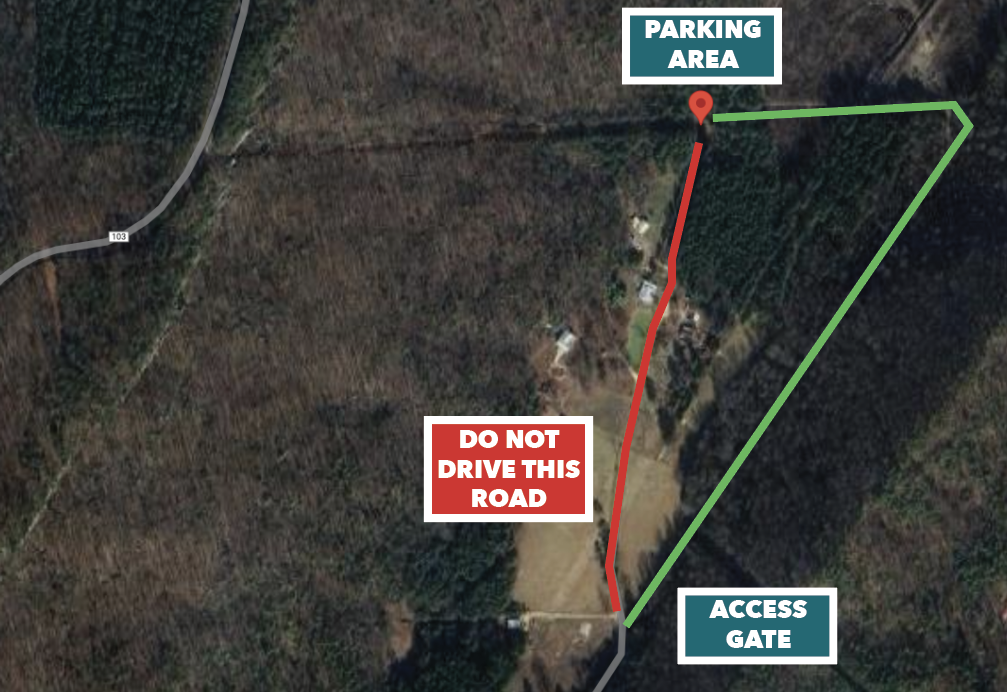
There are only 6 parking spots available. Carpool from the Little River Falls parking lot if the group has multiple vehicles or if the parking area is full.
Once you pass over Little River bridge, continue 3 miles and turn left onto CR15 and continue for 3.1 miles. Turn left at the 3147 sign onto a dirt road and go 0.6 miles. you will go past red/white no trespassing sign and an old stone dam. At the Y, look for a gated dirt road on the right near the beginning of a fence with an SCC sign on it. Use the gate code to unlock the gate, be sure to close the gate behind you.

Continue on this dirt road until you reach power lines and turn left. Follow the road until you reach a fence with a stop sign.

Park here on the left between red blazes on trees. ONLY PARK IN THE DESIGNATED AREA. If the parking area is full, you must go somewhere else. Do not open/drive through any gates (ecxept the entrance with the SCC sign/lock). Do not block any driveways, or park anywhere beyond the red blazes.

Please note, as September 2024, the access road requires a high clearance, 4WD vehicle. The access road and parking area are not on SCC property – It is owned by our neighbors.
What to Expect
The 1,550 linear feet of cliff on the SCC tract starts at the powerline at a slab wall and ends at a free-standing pillar with a short sport climb. The remainder of the cliff-line is privately owned. Jamestown is predominantly a traditional climbing area.
Access is offered in accordance with the Alabama Recreational Use Statute (Alabama Code 35-15-1 et seq.). If you choose to enter this area you are voluntarily choosing to assume all risk of personal injury and/or property loss. Numerous hazards exist on the property, some of which may not be obvious or apparent. These hazards include, but not limited to: steep open cliffs; slippery surfaces; steep and natural walkways, trails, and roadways; loose unstable rocks; falling objects; the possible failure of fixed climbing anchors; and the conduct of other users.
Access notes
-
- Please keep the noise to a minimum and be respectful of homeowners on the cliff above and the valley below
- Do not build fires or fire rings at the base of the cliff
- Do not leave any valuables in car
- Parking lot is located in the bottom field. Please park only in the SCC designated lot
- Keep this area beautiful and clean. Clean up after yourselves, your peers, and your pets. Lead by example and pick it up on the first pass.
- The top of the Jamestown cliff is private land. Do not top out for any reason.
- Do not climb on Alabama Power Company or Lake on the Brow property. It is off limits. No exceptions. Climb only on SCC property.
- No bolting- Jamestown is primarily a traditional climbing area. If you have questions, please contact the Property Managers listed above
Camping
No camping at Jamestown. Beautiful DeSoto State Park and Cherokee Rock Village are a short drive away and have camping facilities.
Guidebook
Dixie Craggers Atlas